| Cobourg I Port Hope I Pt Darlington I Oshawa I Whitby I Frenchmans Bay |
Port Newcastle |
|
Proceeding west from Port Hope to Newcastle Caution is advised when close to shore as a shoal with a depth of 6 feet exists 0.6 miles WSW of the Port Hope eastern breakwater light structure 0.25 miles offshore. The coast west from Port Hope to Otty Point 3 miles to the west (43 °rees 56 minutes N, 78 °rees 21 minutes W) has 20 foot high bluffs. Otty Point forms the highest part of this coastline rising to 70 feet with woods. The next 2.5 miles to the west between Otty Point and Chrysler Point is fairly flat raising inland with the western edges lined with trees. Port Britain is 0.8 miles west of Otty Point and many cottages line the waters edge. There is a submerged water intake 1 mile ENE of Chrysler Point extending 0.6 miles offshore and having a depth over the outer crib of 37 feet. Port Granby lies 1.8 miles west of Chrysler Point and can be distinguished by several houses close to the shore most notably a grey house having a brown roof. Bond Head lies 3 miles further west from Bouchette Point with 50 foot high sand and clay bluffs sloping to the west while farmland is viiable inland. Bond Head is a traffic calling in point for the St Lawrence Seaway control. Caution is recommended at Bond Head as there is a reef with 18 feet of depth extending 0.5 miles offshore here. Newcastle Lights Newcastle Entrance Light (500.8) is privately maintained and on the outer end of the west breakwater in a white circular tower of 16 feet height and a green upper portion. Caution is recommended as the entrance is subject to silting although private dredging maintains depth, there have been reports of much shallower depths at the entrance. 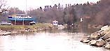
The Port of Newcastle is both scenic and peaceful, popular with boaters of all kinds who enjoy the sight of the century old houses and large trees, which still remain of the old village of Newcastle, 1½ miles away. Chrysler Point is 5.5 miles to the west of Port Hope marked by and heavy woods particular in the gullies, the coast west rises 90 feet where the clay cliffs above the lake. Approximately 0.75 miles to the west of Chrysler Point you can see Wesleyville to the north through one of the occasional clearings on the bluffs. More conspicuous is the main building and chimney of the Wesleyville Generating Station located 1 mile ENE of Chrysler Point. The white chimney rises to a elevation of 664 feet and exhibits white strobe lights. 0.9 miles to the NE of chrysler Point is a microwave tower marked with air obstruction lights. 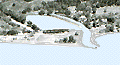
Further to the WSW of chrysler point 3 miles is Bouchette Point rising to 100 feet where the barren point tops the clay cliffs, while there are groups of trees particular in the gullies. West of the Bouchette Point the cliffs drop to the mouth of a creek where small craft can land. The port of Port Newcastle is formed by a bay at the mouth of Graham Creek on the western bank. In recent years this port has been extensively developed and offers exceptional facilities for larger vessels. 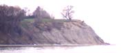
Newcastle harbor is entered between concrete and boulder breakwaters, the eastern one extending 475 feet outwards with the outermost 100 feet having a steel pilings and concrete pier at an elevation of 6 feet. The westerly breakwater is somewhat shorter at 302 feet and having a steel pilings and concrete pier at an elevation of 6 feet. As the entrance passage to the harbor is northwesterly one finds that the westerly breakwater extends further into the lake. The channel between the breakwaters is well maintained and holds its depth to the edges. However because of the dog leg at the entrance caution should be advised when entering in bad weather as there is extremely limited width for two vessels to pass when between the breakwaters. Although the village itself is small it does offer a fair variety of establishments where one may satisfy their appetite or quench their thirst. |
|
Port of Newcastle
|
| Cobourg I Port Hope I Pt Darlington I Oshawa I Whitby I Frenchmans Bay |