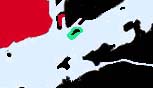
www.cruising.ca CEDAR & MILTON ISLANDS Canadian Hydrographic Charts 1438, 1439 |
|
www.cruising.ca CEDAR & MILTON ISLANDS Canadian Hydrographic Charts 1438, 1439 |
Cedar Island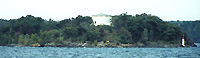
Closest to Kingston, just off Cartwright Point is Cedar Island part of the St Lawrence Islands National Parks with a picnic shelter and 4 camp sites, just a close hop away from Kingston. Unlike most of the islands Cedar is a granite island whose history is part of the defences of Kingston as Cathgart Tower, a circular tower, on the western end testifies. Seeing Fort Nearby on the northern shore and the almost identical tower in Kingston's Confederation Basins one can easily imagine the firepower that could be brought to bear on approaching vessels. 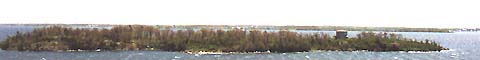
Due to prevalent lake wave you should avoid anchoring other than in the bays. Cedar Island provides two landing areas, the larger of which being at the north end between Whisky Island and the channel dividing Cartwright point. On shore are picnic tables, campgrounds and a shelter. Most people approach from the north channel where the water is deepest. There is a T shaped crib dock in the northern bay, but because, note that it is small and there is no place to anchor if the dock is full. If the north bay is full your second option is on the western side, but has only limited draft. I would point out that the extremely low water levels in 99 were up to 4 feet below datum and the entire Thousand Island area strewn with unexpected rocks, but as of early May 2000 the levels have risen somewhat so it is advised that would be sailors in this area check the actual variation from the charts datum. There is a partly cribbed floating dock allowing access to a stone BBQ and signs leading you to the toilets and sights. When you visit Cedar it is worth a walk as the trail is well laid out with a display and viewing areas of Fort Henry, en route to Cathgart Tower. This areas history is rich and interesting. and we shall provide a more cetailed section later this year. Milton IslandFurther to the east roughly 2.5 miles on the north shore is Milton Island 
Milton Island lies approximately 2.5 miles east of Cedar Island and is also a Park Island. Somewhat triangular in shape, pointing west with a small bay on the eastern end. There are no obstructions around the island except close in-shore. 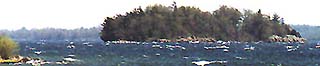
The bay is not overly deep and if you draw more than 5 feet you should consider visiting one of the other nearby islands instead. From a geological point of view Milton is a quartizite island which often gives it a lavender hue when the sun is low. 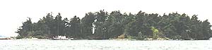
When entering the bay on the northeast end avoid the gravel bars protruding at the entrance by staying midway, and be aware that there is a large boulder just northwest of the centre of the bay. Your best approach is from the south or from the more sheltered northeast. You will find the greatest depth along the south approaching the crib docks. Like all of the park islands it has been well developed and has BBQs, campsites and a shelter, all located on the south arm close to the dock. You will find a lookout on the west end linked by a path. From here your option to sail east are divergent. You can take the north inside route, which is the Bateau Channel or cut eastwards along the north shore of Wolfe Island, passing Cold Bath Shoal on Wolfe Island to the Outside Route. If you choose the outside route you will be able to rejoin the main shiping channel and the Islands and shore of the United States, once you pass Port Metcalf and Beauvis Point. This will bring you to Clayton on the USA shore. |
WOLFE . BATEAU CH . ADMIRALITY . LAKE FLEET . GRENADIER . BROCK . EASTWARD |
Features & Reference |
Cruising guides |
|
|
Sponsored by Canadianet Communications for all your digital image acquisition requirements copyright 1999 2000, 2001 all rights reserved |