
Thousand Island Bridge AreaRaft Island Group |
Thousand Island Bridge AreaRaft Island Group |

If you are approaching from upstream you have a choice of channels around Ash and Wallace Islands. The small craft channel runs to the north of Ash Island wandering between smaller islands the north shore and Ivy Lea and has considerably less current The more direct channel passes between Ash and Wallace Island but does pack a fair current which can make things exciting for smaller sailboats with limited power. You can feel the current tug at you as you slip between the islands as you pick up speed, not dangerously but noticeable. 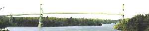
Within the Thousand Island area the narrowest point in the St Lawrence River is in the Thousand Islands Bridge area where the Canadian and American shores are a scant 4 miles apart. To the east of the bridge is where the river actually begins, with the current rising to over a knot downstream of the bridge. Constance IslandSo close to the bridge as to have the footings embedded on their rocks lie Constance and Georgia Islands. The docks on Constance Island are east (downstream) of the bridge and located on the south-east end, while the southern side dock provides fairly deep water but the smaller docks on the north side provide only two or three feet of depth. 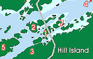
For a larger scale map click on one to left A word of caution, the bridge clearance is only 41 feet and with a 1 knot current your approach from upstream can be deceiving. As nice as the islands are, I have always avoided them, as it is like being trapped under an expressway with the bridge traffic rumbling by overhead. Well worth a stop but not a long stay. There is a park with fresh water from a well, a picnic shelter, toilets and a BBQ. In comparison to many of the island docks there is a lot of space, but a little too civilized for my idea of cruising, having the bridge overhead. On the other hand when actually visiting these islands last Sunday, the amount of noise was far less than I had anticipated making the location well worth visiting. You can pass between Constance and Huckelberry Islands if you are inclined to do so, using the channel which had 5 to 6 feet of water with the occasional spring break-up log hiding on the bottom . However as always be careful as no chart will be able to plot the vagaries of such a dynamic environment and stuff gets caught there. 
If you wish to visit with a deep keel sailboat good advice dictates that you choose the narrow and deep channel to the south of Huckelberry between Reveille Shoal located to the north of Pine island. 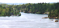
The photo to the left is east of the Hill Island Bridge looking between Huckelberry and Hill Islands you can see how this passage looks. Click the image for a large sized gallery image of this picture. Georgina Island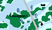
Georgina Island lies upstream of the bridge and has docks on both the north and south sides of the island with two locations the north side. All the docks are linked by a well kept nature trail which winds through the hilly terrain. 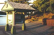
West of the bridge on the north side in a small bay with two crib docks with adequate water for most boats on either side of the docks. There are no obstructions hampering your approach and in spite of my prior misgivings we chose to tie up here to see what it was like. The current had almost no bite as we approached the dock and the water is crystal clear. We ended up on the outside (west) side of the crib dock. 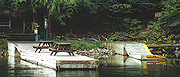
Georgia is a surprise as all of the facilities are intact and we spent an enjoyable evening aroud the "stove" in the picnic shelter with our neighbours. Even boat Cat was impressed (which is not easy) taking longer walks along the trails than she does at the farm. There are two smaller docks with limited draft at the back of the bay with the west one side reserverd for parks personnel. 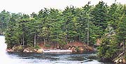
On the east side of the bridge there is a large floating dock with deep water but having a rock shoal to the east of it, should your approach be from downstream. Dring our visit a 30 foot keel boat very successfully anchored in the small bay only 20 feet from dshore, it should be ideal as you can easly set stern lines ashore. On the southern side of the island there are almost corresponding docks located one above and one below the bridge. The one west (upstream) is in a small bay with deep water and enough room for careful anchoring in a gravel bottom. A line from your stern ashore would be a good idea due to the limited room, and current. The second and downstream, east of the bridge is a large floating dock with only the outside of it usable offering 4 to 6 feet of water. 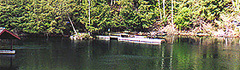
With all these docks in such a concentrated area Georgina is an interesting walk, with the normal park facilities available including campsites. Most of the Thousand Island geographic features can be found in this island. Alternative Anchorages for Bridge Area. If the docks under the bridge are full you can tuck yourself away, by anchoring somewhat upstream on the east side of Wallace Island. You will find a small bay on the east side of the island but when approaching be careful as there is a shoal between the inside points of the bay which require careful foredeck observation when entering the bay. Hill Island
Hill Island is one of the largest of the Thousand Island Parks. The island shoreline is rugged and the wildlife enjoy a somewhat undisturbed existence with a range of fauna from water snakes to white tailed dear and most everything in-between. To visit Hill Island there is but one point of egress which is Battermans Point, located on the northwest tip of the island, which is not labeled on most charts. The dockage here is shallow limited to 3 to 6 feet on the south side of the point near an old mansion. once the site of movie glory. You will find the usual park facilities here with trash bins, toilets, BBQs and a picnic shelter. The Island offers a long walk for those interested in rambling to the west along a roadway leading to the bridge. At the bridge you can ride an elevator to the observation platform which has a reasonable restaurant, tourist information, and gifts shop. In some ways it is worth the walk or ride as this part of the islands gives the voyage by boat a different perspective. Bucks Bay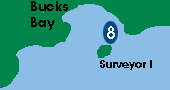
Downstream of the bridge on the mainland shore, tucked behind what is perhaps the most beautifuly landscaped cottage in the islands is Bucks Bay. In September 2000 there is a intensive construction project taking place on the east corner of the bay, but they stop work fairly early. If all else fails and you need to drop your hook for the night there is a comfortable anchorage in deep water on the off the eastern shore of bucks Bay sheltered by surveyor Island just east of the bridge on the mainland. |