|
|
|
|
|
|
|
|
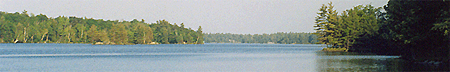
From here S163 is found on the north shore as makes a gentle bend and opens up for the balance of the run to Swift Rapids lock. . As you leave Wier's Bay headed down stream for Swift Rapids the channel the river widens into a respectable size lake above the lock. There are no hazards on the upstream approach to Swift Rapids Lock 43 which is located on the north side of the water. Swift Rapids is a lock that has few visitors that do not arrive by boat as land access is extremely difficult. We ventured in the hard way in creating this guide and report that all published reports of poor roads are accurate. In order to reach Swift Rapids by land you need to allow an entire afternoon and not attempt it in the family car! 
From the last excuse of a county maintained gravel road there is 14.5 kilometers of a private service road for the Hydro dam that is an adventure in off roading. As you wind back into the bush the rocks become larger and the narrow road winds between high trees, scaling steep climbs over massive mounds of granite . It took me the better part of 2 hours to negotiate the 14.5 KM and there were times that I had to get out to check the depth of the water over the road thanks to the beavers who think the the road is a great starting place for a dam. |
| ID | Mile | Kilometers | lift | length | Sill Depth | Preferred side |
| # 43 | 224.5 | 361.5 | 47' | 120' | 9' | Starboard |
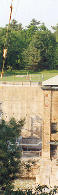
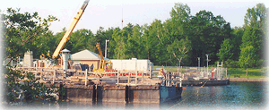
Swift Rapids, lock 43 is a modern lock that was completed in 1965 and is the deepest conventional lock on the system having 47' of lift. The current lock was built in 1965 to replace a marine railway constructed during World War l. Facilities at Swift Rapids are limited to the lock side tie up's however there is no garbage pick up. The area is very remote and has a number of dangers for the unwary. Just being this deep bush has its own problems and it is a good idea to keep your pets on a leash and not to wander too far away from the lock area. Once downstream of S163 there is a short run to Severn Falls. The channel widens into Russian Bay where it makes a sharp turn to following the south shore, marked by S157. You pass between a small island and the south shore. As the channel opens out watch for S151 marking a 2 foot shoal north of the channel, off Avery's Bay. At mile 226.1 there is a small island having day mark S150 on its SE or upstream end, and S148 downstream. On exiting Avery Bay stay mid channel at S147 as the channel narrows again. CAUTION: Mile 227 in the Flat Rock Rapids Area, the channel becomes narrows with rocks lurking at the channels edges. A SPEED PATROL ZONE begins at S143 and day mark S144. |
|
You are now on the approach to the small community of Severn Falls. 
Severn FallsS136 marks the beginning of speed control up stream SPEED PATROL ZONE . CAUTION:Buckskin Island mile 228.9 is marked by S131 & S130. The channel passes the island to the south. CAUTION: Rock shoals are close to the channel in the area of day marker S127 and S128 where the channel is tightly constructed. 
The small community of Severn Falls is tucked on the south side of the river, off R S138 at mile 228, in a slightly wider elbow. Severn River is ideally positioned as a stop being an easy days run to Big Chute. Although small in size this tiny community makes up for it with a commitment to transient trade from both water and road. The community is active in the summer fun and hosts a popular poker run BBQ each year. 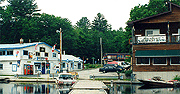
The harbour area is made up of several docks protruding from shore at an angle. There is no protection from wake at any of the docks. S136 marks the beginning of speed control up stream SPEED PATROL ZONE. Starting from upstream the first of the docks belongs to Severn Falls Motel (705) 686 7995. Depth along the dock is 12 to 15 but space is allocated to motel guests first making transient dockage questionable on any given day. The motel offers boats and motors for rental. 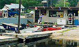
Severn Falls Marina & Metal Works Inc.is open 12 months a year and under new management. They have really done substantial renovations over the past 10 months including upgrading the gas station to 2006 TSSA standards and provide mid grade gas not only to boats but road traffic or snowmobilers. The boat ramp and surrounding area has all been re paved and access is convenient, clean and safe. There is now a small marine supply/hardware store which caters to boaters and local cottagers. Severn Falls Metal Works Incise a full metal shop provides metal fabrication and welding with a specialty of custom permanent and/or floating steel docks. As a final service they provide barge service for moving, material handling, or anything else needed to be transported on the river. 
The government dock is managed by the River Emporium and provides transient dockage for approximately The River Emporium (705) 686 3900 provide transient dockage for up to 15 boats. et to the north side of the small cove. 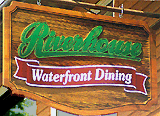
The Riverside Restaurant is located at the end of the dock. The restaurant overlooks the river providing a peaceful charm. They are licensed and have a varied menu that covers the whole gambit of tastes. 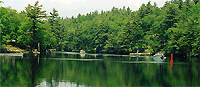
From Severn Falls to Big Chute is roughly 4 miles of remote beauty. The waterway winds through the deeply wooded countryside. Continuing downstream, the channel bends northward then west into Dinnertime Rapids. Day mark S123provides a sight line for the entrance to the rapids. You want to continue north until you pretty much square up and can see down the rapids. Don't go too far as there is a 2' rock off the small point of land on the down stream side, not far from where you will want to be. The north shore has rocks and shoals are marked by S121 and S119, again at S115 near Lost Channel Landing. Lost Channel Landing (to the south) and Lost Channel (to the north) mile 230.5 offers opportunities for exploration and anchorages. Lost channel Landing is a narrow finger of water the stretches south from waterway. It is spanned close to the outer end by a cable with 43' vertical clearance and holds 6' of water (depending on waterway datum adjustments) for most of its length. The roughly 5 miles of Lost Channel up the channel to Cain Lake is one of those places that make it all worthwhile. As you make the turn from the main channel you want to favor Chad's Islands and be west of the entrance to Lost Channel Landing. There are a series of rock almost mid way between the shores before the bay narrows to a gap. Normally rocks these have the bleach bottle markers set by locals. The water is amazing in here making the bottom easy to read. please exercise caution as like ever where in this area rocks may appear from a considerable depth. There is an island perhaps a half mile from the entrance with a 74' tall antenna on the south point. You want to stay east of the island as you progress north across the small bay. The north end of this bay has a narrow 3' deep channel leading north into Cain Lake. The Lost Channel makes a bend to the west at approximately the one mile mark and continue back to where it finally terminates in a stream. Returning to the Main down bound channel. S114 is on the south shore just downstream of the Lost Channel Landing entrance. The main channel rounds Copp Point, mile 230.8, then into Copp Bay before turning west crossing the south end of the bay. As you cross the bay day marks S108 & S110 are located on the south shore. S106 and the last narrow channel before reaching Big Chute basin at S102 and S101. 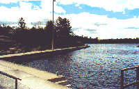
At mile 232.2 the channel opens up into the Big Chute Basin and the holding area for vessels taking the marine railway to go through to Port Severn. |
By E-Mail: Please use mail us @ hotmail