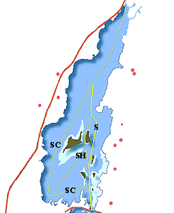
If you wish to follow the alternative course your markers are a series of SH buoys beginning with R SH 6 followed SH 1, 2, 3 & 4 to the west of Horseshoe Island
The main channel itself lies to the both east of Horseshoe Island for a distance of 2.5 miles. Keep to the east of the series red buoys S298, S296 & S294 marking a shoal area having one point having less than 2 feet of water to north east of Horseshoe Island.
Once past the shoal the channel follows a gentle "S" curve as you swing west past the headland of Geneva Park which has a YMCA camp on its east side.
At mile 203.5 is the red flashing SC RGR (2 long & 1 short sequence) bifurcation buoy marking the north end of the alternate SC/SCS channel to Orillia.
Your heading is roughly north 19 ° until you reach G S293 which indicates western edge of the Limestones a shoal area. From here to the entrance of the canal and Washago there are a series of shoals and rocks to either side of the channel. The first is R S292 marking a rock and 3' shoal to the west.
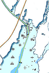
Beginning roughly mile 206 north to the canal entrance you will begin a series of buoys known locally as the Bowling Alley. KEEP IN CHANNEL water depths vary from 2 to 4 feet with a fair selection of rocks to keep you honest. At the north end of the lake there are two Flashing Green range lights having an elevation on 10 & 40 foot towers.
Washago
It would be hard to miss the entrance to the canal here with substantial land fill breakwaters located on either side of the channel. CAUTION to reach the marina located at the west end of the break wall you MUST ENTER FROM THE CHANNEL near buoy S260. There is often less than one foot of water directly out from the marina toward the main channel.
Very shortly after entering the canal you reach the
Highway 11 bridge, 24 ft clearance with a public wharf on the north shore. There are no facilities at the here, there is considerable road noise and passing boats make it rough if you choose to tie-up here.
Above the bridge is a shallow tributary of the Severn River marked by S259.and is not navigatable. The canal runs through wooded banks with little along them until mile 209 where there is a railway bridge.
Canadian National Railway Bridge
| ID |
Mile |
Kilometers |
Clearance |
Position |
| CNR |
209 |
336.48 |
14' |
Normal Open |
From here it is wooded banks to Lock 42.
Channel to Orillia SC Buoyage
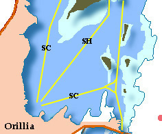
We will describe this channel first from the south as leaving Atherley Narrows and the SCS RGR bifurcation buoy just west of the main channel.
Your course is constricted by 4 & 5 foot shallows which give way to extremely shallow water between Couchiching Point and Heron Island. You must stay between Red SC 12 to the north and Green SC 15 to the south (off Couchiching Point.
From here you have a clear run to the stone breakwall at Couchiching Park marked by SC 6 and SC 9.
|
