|
|
|
|
|
|
|
|
|
|
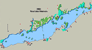
You have reached the complete Rice Lake Page, which contains information about all the harbours and marinas, many of which are not accessible by larger craft. You may pick up the guide at the west exit of Rice Lake Here. You have reached the shore crawlers guide to boating on Rice Lake, for our readers who enjoy an accessible recreation destination with fishing and accommodation. If you want to head directly upstream putting this lake promptly under your keel you can go directly to where you pick up FIR at the mouth of the Otonabee River . Rice Lake got its name for the huge wild rice beds that early native peoples harvested. The lake is roughly 20 miles long and three miles wide making it the second largest lake in the Trent Severn system. For those of you headed upstream into the Otonabee River and Peterbourgh we will cover the direct route first. However the more we explored the more we found there is to this shallow lake with its multiplicity of smaller established harbours. If you are used to the great lakes a word of caution in these sheltered shallow lakes. Given a fair wind the short choppy waves it can be pretty rough. There are numerous small islands throughout the lake and upon entering from the east it is hard to separate the three islands that dominate the horizon. They are Margaret, Grasshopper and Sugar Islands 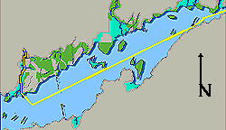
As you leave the mouth of the Trent River entering Rice Lake, clearing T 415 you are in the lake where your course will carry you along the south shore passing Morrow and Webb Bays to your south. On the north shore at Birdsalls Point 44° 16'N. 78° 04'W. there is a public wharf with a break wall to the west making it a good place to wait out bad weather if need be. 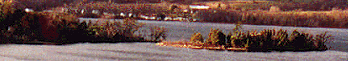
Paralleling the south east shore your course line, narrows to pass the southern tip of Margaret Island. 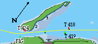
The passage between Margaret Island and the south shore of Rice Lake enters a SPEED ZONE followed by marked marina symbol on chart mile "59" . Many older guides have not given McCracken Landing its dues. I did not really see a viable public dock here , however there is Lang's Marina. 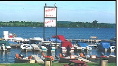
Lang's Marina (905) 352 2308 1 (800) 898 4995. website is a nicely kept general store and fishing boat STOP. There is six feet of water at the outside beside the fuel dock which should accommodate 3 or 4 fair sized cruisers. (photo by Langs Marina) 
Lang's Marina is an easy stop with a 150 long gas dock close off the channel with a clear approach if you simply turn toward the marina T 421. Langs is a well kept little marina with good facilities for the summer user. They have a camp ground, cottages, rental boats of all descriptions and a swimming pool and showers. If you are down bound the McCracken Light T 423 is 0.3 miles SW of the public landing and found with 30 foot elevation on tower with port hand day beacon.
The channel pinches quite dramatically to the immediate east of McCracken Landing. The building you see in the photograph looking west through the gap is mid way along the shore of Margaret Island at mile 59. If your up bound to Peterborough your the next 9.5 miles gives you a chance to bring her up above idle, the Otonabee River FIR light should be approximately 228° true.
Content of this Photograph left to right:
|

|
As you come abreast of T 424 seen on the right of this photograph, The marker is on a jetty at the south end of Margaret Island. The next island behind it is the south tip of Grasshopper Island which you will leave to your port side. Sugar Island appears well down course directly in the middle on the photograph. your course will take you between the islands you see in the distance. 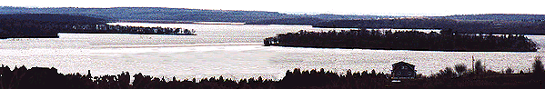
The Photographs above shows: The passage between Grasshopper Island and the North Shore of Rice Lake approximately mile 60 with one of the houses which make up Robins Landing silhouetted in the foreground. Grasshopper Island is right in the background while you see the northern tips of White, Hickory and East Grape to the left. The chart marina symbol shown at Robins Landing is the Muskie Bay Resort. (905) 352 2221. Muskie Bay has good deep water berths for boats up to 30 feet with a clear approach. It is in some ways a typical Rice lake marina with power water, camp ground facilities and rentals. The marina has an L shaped rock break wall which extends parallel to the shore in a north south direction and connects to the shore on the north end. 
The main channel passes to the north of Hickory which is the largest in picture and East Grape the small island to the centre left of photograph. In the distance on the north side of your course is Sugar Island which lies off the mouth of the Indian River on the north shore of Rice Lake. 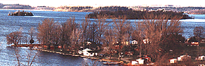
Dunnette Landing 44 #176N, 16'. 78 ° 04'W is to the SSE of White Island. The Alpine Marina & Resort is 0.8 miles NNE of Dunnette Landing which has 5 feet of water with limited dockage, camping, boat rentals, phone, store, gas, showers and laundry. The other resorts in the area are, Glengarry Cottages which has 3 4 - 5 feet of water with limited dockage, camping, boat rentals, phone, store, gas, showers and laundry. To the SW of the landing is Cardinal Cottages who are strictly seasonal. Sandercock's Tourist Resort has 4 - 5 feet of water with limited dockage, camping, boat rentals, phone, store, gas & showers. With south west prevailing winds there is what looks to be an excellent deep water anchorage between White Island and the shallow bay bordered by Alderville Territories Marinas. As yet we have no solid information on their services. If you are continuing SW along the south shore it is best to go back the way you came in, using the north east to the main channel rather than trying to negotiate the passage to the west of White Island which shows only a 4 foot deep channel clear northwards. The main channel and deep water lie close north of Rack Island, across the lake from you are Sugar Island with Serpent Mounds . 
There are 4 marinas indicated on both Shearer Point to the east and Curtis Point west off the south shore which we have not checked out at this time. They are Sunset Cove which has 3 feet of water and limited dockage. The small resort has camping trailers, phone, convince store, boat rentals, with trailers cottages and gas. Idle Hours Resort lies 0.4 miles south of Shearer Point and offers nothing for transients. Curtis Point Cottages is just east of Curtis Point and again offers the typical rentals, a snack bar, showers and laundromat. The main feature of the shoreline in this section has be to the Golden Beach Resort which is 1.5 miles NNE of Harwood and marked with the Marina symbol on hydrographic charts. For the transient they dredge the approach to 6 to 8 feet and have dockage for a couple of fifty footers with 30 amp power. Golden Beach Resorts and Condominions is a truly expansive recreation lifestyle development. This is top of the line waters edge development. Golden Beach Resort Web site here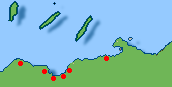
West across the Goose Creek marsh and stream lies Sugar Point 1.8 miles to the north west. Harwood was the southern terminus for the long abandoned Railroad bridge that creates a string of hazardous semi submerged pilings and other obstructions. |
|