|
|
|
|
|
|
|
|
Lock 13 Cambelford
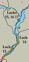
Located about a mile from Cambelford Lock 13 has no facilities other than wash rooms. We like Lock 13 particularly on the east upstream side away from traffic where the cat can have an undisturbed ramble over the hillside. There is also a great view of the river below,with Cambelford in the distance. However, there is not much else around ,with town approximately a mile distant. Other than the danger of stepping on a turtle which are plentiful at Lock # 13 it is a perfect stop. 
From Lock #13 the river takes a definite turn north leaving T243 between you and the west shore then angles east, keep slightly mid river from T244 & T244 on the east shore just before a small spit of shoreline, as there are rocks between here and the shore. The course lies along the east bank with a fair bit of turbulence and even with only 4 boats waiting kibbitzing in the channel take care. Lock # 14 Crowe Bay
|
|
As you leave the top of Lock 14 Crowe Bay it is a bit of a surprise as the dam creates what appears to be a fairly wide lake with cottages close by on the east shore. Here a narrow river below the dam fills with water from both the Trent and Crowe River's. Your course leads close to the east shore with cottages almost within reach, with two small islands Clarks and Peloe Island dead ahead. No matter the traffic hanging in there as are rocks off to the west, just before Peloe Island, Making any deviation strictly for locals. 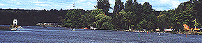
You will follow the east shore of the river leaving Armour Island between you and the shoreline. Just stay with the buoyed channel until you pass T262 as there are numerous rocks and shoals. Once you clear T262 the course opens out for the rest of the run north to Lock #15. As you approach T 269 you need to keep an eye open for the entrance to Lock #15 which is to your west, as the wide mouth of the Crowe River appears to be the main waterway, particularly when there are a lot of small fishing craft around. As you turn into the Trent River the channel is against the south bank which rises above you. There is usually plenty of space below lock # 15 to tie up if you loose out there are plenty of spots in the mouth of the Crowe River where you can anchor. Lock # 15 Healey Falls
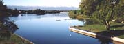
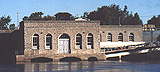
The next three locks are a good place to have fenders and lines rigged both port and starboard if possible. Not just because there can be quite a surge when they change locks but every time we have come through there seems to be someone who has trouble handling their boa,t for one reason or the other. The entire set of three locks might as well be consider a single exercise and except for waiting let alone spending the night the centre basin has little to offer. Upstream of the blue line there is a 300 foot long retaining wall whish does have picnic tables and a grassy area. 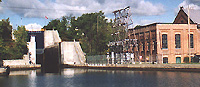
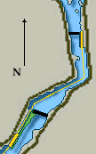
The area between lock 15 and the step locks of 16 & 17 remains fairly deep throughout on the east side; to the west in the basin proper depth shoals to 4 or 5 feet along the west wall with a very shallow 1 foot patch perhaps two thirds of the way along. With the exception taking a few pictures and catch our breath we never stop. NOW, you want to be on your tip toes. The short turning basin passes quickly and often you will go directly into the first of the second set of flight locks, Lock #16 and # 17. The entire lift or drop operation runs quickly and smoothly. However, you do not want to be day dreaming here. 16 & 17 Healey Falls
Above Healey Falls lock it is possible to tie up to the yellow railing on the pump house side under most conditions. You do not want to tie up here if there is a lot of water in the spring due to a strong current. If you do tie up it is a great stop for a bit of walking as the falls themselves are very close by. 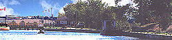
As a personal note, if you have a fair bit of wind from the north or west be prepared for a tricky stop as the wind tends to suck over the high lock wall creating a downdraft or artificial wind increase. With 20 knots astern Edgar could not hold the stern line as I went forward and was pulled over the side. Quite thrilling as he sinks like a stone and I was I below the keel before I got a grip on him to pull him up. Worse because of the number of boats and traffic, the lockmasters did not realize that anything had happened until I had gotten him back to the ladder in the lock. Now we were lucky, and my emergency cast did loop over a bollard, but I consider that luck - be warned! |